
Salt wind

關於鹽風
ABOUT SAIT WIND
本專題聚焦於台灣西南沿海地區,探討因氣候變遷與長期人為開發所形成的高鹽分土壤環境,並以「鹽分地帶」作為研究核心。透過文獻分析、地方田野調查與視覺設計的方法,系統性整理區域自然條件與人為活動交互影響的脈絡,進而提出「鹽土三態」概念,包含鹽土風化、鹽土晶化與鹽土馴化,分別從土壤變化、產業積累與農業韌性三個層面,引導觀者理解鹽分地帶的形成背景與演變歷程。設計成果結合特殊出版品、資訊圖表、互動體驗與數位推廣,並融入體驗學習與環境教育推廣機制,讓觀者透過實際參與與視覺理解,加深對鹽化議題的認識。期望透過本計畫促進大眾對台灣西南沿海土地環境價值與人文意義的再認識,並引發對環境永續與地方發展的持續關注。
This project focuses on the southwestern coastal region of Taiwan, exploring the high-salinity soil environments shaped by climate change and long-term human activities. Taking “saline landscapes” as its core theme, the study integrates literature review, field research, and visual design methods to systematically examine the interplay between natural conditions and human interventions.Based on this analysis, the concept of the “Three States of Saline Soil” is proposed: weathering, crystallization, and adaptation. These three states correspond to soil transformation, industrial accumulation, and agricultural resilience, guiding audiences to understand the formation and evolution of saline landscapes.The design outcomes combine experimental publications, infographics, interactive experiences, and digital media, incorporating experiential learning and environmental education approaches. Through both visual interpretation and hands-on engagement, users can develop a deeper understanding of soil salinization.This project ultimately aims to foster renewed awareness of the environmental value and cultural significance of Taiwan’s southwestern coastal landscapes, while encouraging ongoing attention to sustainability and regional development.
臺灣鹽分地帶紀錄片
TAIWAN SALINE LANDSCAPES DOCUMENTARY
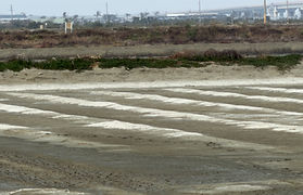
本設計以數位影像為主要傳達媒介,透過空拍與紀錄影像呈現雲嘉南鹽分地帶地景變化,捕捉鹽地環境與人地互動,展現鹽化土地從形成、累積到復育轉化過程,呈現土地環境變遷。
This project uses digital imagery as its primary medium, employing aerial and documentary footage to present the changing landscapes of the Yunlin–Chiayi–Tainan saline region. It captures the interaction between environment and people, revealing how salinized land evolves from formation and accumulation to ecological recovery, reflecting broader environmental transformation.
何謂臺灣鹽分地帶
WHAT ARE TAIWAN’S SALINE LANDSCAPES
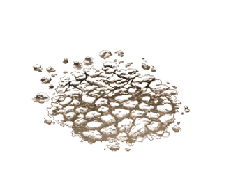
鹽分地帶是指土壤中含有較高鹽分的區域,常見於沿海或地勢低窪的地方。當海水滲入土壤,或水分在高溫下蒸發後,鹽分會逐漸��累積,使土地變得乾硬,甚至在表面形成白色結晶,不利於作物生長,然而這樣的環境也促使人們發展出不同的利用方式,並逐漸形塑出具有地方特色的生活樣貌與文化景觀。
Saline landscapes refer to areas where the soil contains a high concentration of salt, commonly found in coastal or low-lying regions. When seawater infiltrates the soil, or when moisture evaporates under high temperatures, salt gradually accumulates, causing the land to become dry and hardened, sometimes forming white crystalline deposits on the surface. This condition is unfavorable for crop growth; however, it has also led people to develop alternative ways of utilizing the land, gradually shaping unique local lifestyles and cultural landscapes.

臺灣鹽分地帶分布
DISTRIBUTION OF SALINE LANDSCAPES IN TAIWAN

台灣鹽分地帶地圖
Map of Saline Landscapes in Taiwan
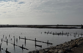
鹽分地帶主要分布在台灣西部沿海地區,從彰化一路延伸到屏東,形成一條沿著海岸線展開的帶狀區域,其中以雲林、嘉義與台南最為集中,是台灣最具代表性的鹽分地帶。這些地區多半地勢低平且靠近海洋,海�水容易滲入土壤,再加上氣候炎熱、蒸發快速,使鹽分逐漸累積於地表。隨著時間推移,土地性質逐漸改變,進而形成鹽化現象。
Saline landscapes are mainly distributed along Taiwan’s western coastal regions, extending from Changhua to Pingtung in a belt-like pattern along the shoreline. Among these areas, Yunlin, Chiayi, and Tainan are the most concentrated and are considered the most representative saline landscapes in Taiwan. These regions are generally low-lying and close to the sea, making them more vulnerable to seawater infiltration. Combined with the hot climate and rapid evaporation, salt gradually accumulates on the soil surface. Over time, the nature of the land changes, eventually leading to soil salinization.
鹽土三態介紹
INTRODUCTION TO THE THREE STATES OF SALINE SOIL
鹽土風化
鹽土晶化
鹽土馴化


Saline Soil Weathering
Saline Soil Crystallize
Saline Soil Domestication
使用者能理解土壤鹽化的形成原因與環境條件,建立對土地變化的環境判讀能力。
Users are able to understand the causes and environmental conditions of soil salinization, and develop the ability to interpret changes in the land.
使用者能理解鹽化地景形成新的生態系統,認識不同鹽地景觀的功能與價值。
Users are able to understand how saline landscapes form new ecological systems, and recognize the functions and values of different saline environments.
使用者能理解耐鹽農業如何回應土地條件變化,並思考在支持永續土地利用上的角色。
Users are able to understand how salt-tolerant agriculture responds to changing land conditions, and reflect on its role in supporting sustainable land use.
鹽土風化
SALINE SOIL WEATHERING
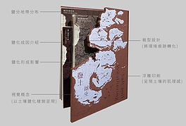
此階段聚焦「鹽化如何發生」與土地劣化的環境根因。設計透過資訊圖像與敘事裝幀,將地下水變動、海水入侵、蒸發與鹽分累積等過程轉譯為可閱讀的環境故事,讓使用者建立對鹽化成因的理解。透過分層結構的裝幀設計,從海岸地景、農田環境到土壤剖面逐層深入,並搭配鹽土色票作為觀察工具,使鹽化不再是抽象數據,而是可被辨識與比較的環境現象。
This phase focuses on how salinization occurs and the environmental causes of land degradation. Through infographics and narrative book design, processes such as groundwater fluctuation, seawater intrusion, evaporation, and salt accumulation are translated into accessible environmental stories, enabling users to understand the causes of salinization.A layered binding structure guides users from coastal landscapes to agricultural environments and further into soil profiles, allowing for a gradual and in-depth exploration. Paired with a salinity-based color palette as an observational tool, salinization is no longer abstract data, but a visible and comparable environmental phenomenon.


鬆軟富含生命力健康土壤
Loose, fertile, and healthy soil rich in life
表層略泛白鹽分開始累積
Slight surface whitening with initial salt accumulation
鹽蔓延土地緊縮養分流失
Salt spread, soil compaction, and nutrient loss
裂縫與鹽交錯土地開始硬化
Cracks and salt as soil hardens
鹽分堆積水氣難以滲透
Salt accumulation limits moisture penetration
鹽土風化套組
SALINE SOIL WEATHERING COLLECTION
設計透過資訊圖像與敘事裝幀,將地下水變動、海水入侵、蒸發與鹽分累積等過程轉譯為可閱讀的環境故事,讓使用者建立對鹽化成因的理解。並透過分層結構的裝幀設計,從海岸地景、農田環境到土壤剖面逐層深入,並搭配鹽土色票作為觀察工具,使鹽化不再是抽象數據,而是可被辨識與比較的環境現象。
Through infographics and narrative book design, the project translates processes such as groundwater fluctuation, seawater intrusion, evaporation, and salt accumulation into accessible environmental stories, enabling users to understand the causes of salinization.A layered binding structure guides users from coastal landscapes to agricultural environments and into soil profiles, allowing for a gradual and in-depth exploration. Paired with a salinity-based color palette as an observational tool, salinization is no longer abstract data, but a visible and comparable environmental phenomenon.

套組分解圖
Exploded View of the Set


體驗組總覽
Experience Kit Overview
裝幀細節呈現

Bookbinding Details


鹽土晶化
SALINE SOIL CRYSTALLIZE
此階段呈現鹽化後地景與生態如何被重新組構。透過「結晶」隱喻與材料觸覺體驗,讓鹽分沉積的時間性與地景變化被身體感知,而不僅止於視覺理解。裝幀內容結合地景圖卡與生態功能對照,讓使用者理解鹽田、潟湖、濕地與紅樹林等環境如何各自承擔不同生態角色。
This phase presents how landscapes and ecosystems are restructured after salinization. Through the metaphor of “crystallization” and tactile material experiences, the temporality of salt deposition and landscape transformation is perceived through the body, rather than understood solely through vision.
The binding content integrates landscape cards with corresponding ecological functions, enabling users to understand how environments such as salt fields, lagoons, wetlands, and mangroves each perform distinct ecological roles.

濕地
Wetland

鹽田
Salt Fields

瀉湖
Lagoon

沙洲
Sandbar

紅樹林
Mangrove
鹽土晶化套組
SALINE SOIL CRYSTALLIZE COLLECTION
透過結晶隱喻與材料觸覺體驗,讓鹽分沉積的時間性與地景變化能被感知,而不僅止於視覺理解。裝幀內容結合地景圖卡與生態功能對照,並搭配體驗材料展現鹽地獨有的礦物美感與氣候痕跡,喚起人們對鹽分地代生活智慧與產業美學的重新思考與想像。
Through the metaphor of crystallization and tactile material experiences, the temporality of salt deposition and the transformation of landscapes can be sensorially perceived, rather than understood solely through vision.The binding content integrates landscape cards with corresponding ecological functions, accompanied by experiential materials that reveal the unique mineral aesthetics and climatic traces of saline environments. This approach invites reflection on the wisdom of living with salinity and reimagines the aesthetic and cultural value of salt-based industries.

套組分解圖

Exploded View of the Set


體驗組總覽
Experience Kit Overview
裝幀細節呈現
Bookbinding Details


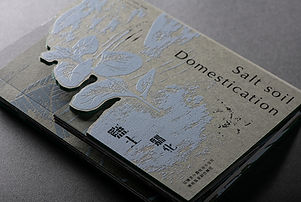
鹽土馴化
SALINE SOIL DOMESTICATION
階段回到人與土地的關係,呈現耐鹽作物與地方農業如何回應鹽化環境。透過出版敘事與乾製物體驗組,將作物特性、耕作策略與加工�應用轉譯為可被品嚐與感知的日常經驗。設計同時引導使用者思考個人如何支持此類農業模式。
This phase returns to the relationship between people and the land, presenting how salt-tolerant crops and local agriculture respond to salinized environments. Through narrative publication and a dried-material experience kit, characteristics of crops, cultivation strategies, and processing applications are translated into everyday experiences that can be tasted and perceived.The design also guides users to reflect on how individuals can support and engage with such agricultural practices.


小番茄
Tomato

冰花
Ice Flowers

火龍果
Dragon Fruit

甜菠菜
Sweet Spinach

洋香瓜
Cantaloupe
鹽土馴化套組
SALINE SOIL DOMESTICATION COLLECTION
呈現耐鹽作物與地方農業如何回應鹽化環境。透過出版敘事與乾製物體驗組,將作物特性、耕作策略與加工應用轉譯為可被品嚐與感知的日常經驗。設計同時引導使用者思考個人如何支持此類農業模式。
This section presents how salt-tolerant crops and local agricultural practices respond to salinized environments. Through narrative publication and a dried-material experience kit, the characteristics of crops, cultivation strategies, and processing applications are translated into everyday experiences that can be tasted and perceived.The design also encourages users to reflect on how individuals can support and engage with such agricultural models.

套組分解圖

Exploded View of the Set


體驗組總覽
Experience Kit Overview
裝幀細節呈現

Bookbinding Details
作品總覽
PROJECT OVERVIEW
